Once upon a time in Brighton, which was to become east Rochester, two ponds existed where now highways criss-cross one another. Much like the famed Willow Pond on Thomas Creek, these ponds were artificial, created by well-to-do families to ornament their extensive gardens.
These two ponds existed on two properties, north of the East Avenue extension past Winton Road, and south of the Rochester, Syracuse and Eastern Railway branch.

Red: Clarke/McInerney Pond, No. 2100 East Avenue.
Green: Noeth/Ingle Pond, No. 2200 East Avenue.
Blue: Creek inflow to No. 2200 East Avenue pond.
https://photo.libraryweb.org/rochimag/rpm/rpm00/rpm00367.jpg
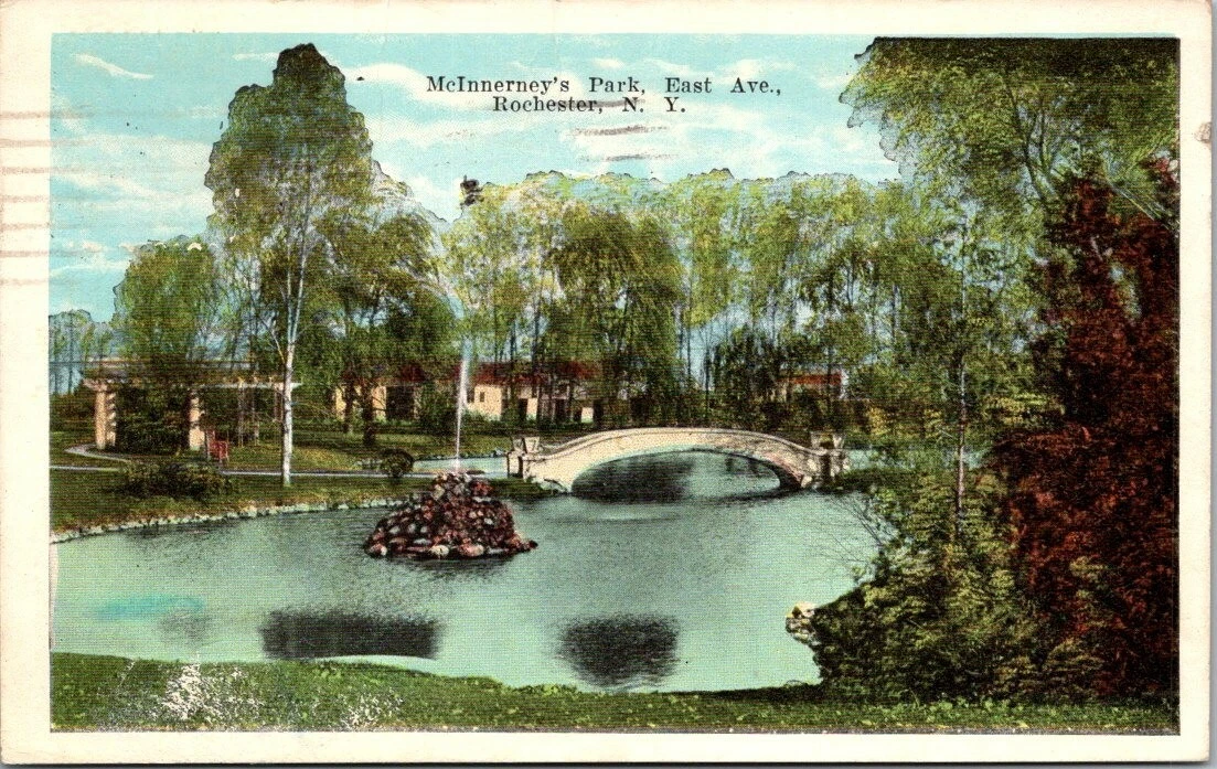
While the Clarke/McInerney Pond at No. 862/2100 East Avenue was apparently supplemented by municipal water sources through a stunning tall fountain, the Noeth/Ingle garden pond was fed with water from a creek to the southwest, which was culverted beneath East Avenue to the pond.
From the ponds, water traveled along two branches of this creek to a confluence between the R.S&E. and Central New York railroads, the latter of which the joined waterway culverted beneath to continue northeast, eventually draining into Irondequoit Creek.
[Edit: This next section predates my July 7th update, and is inaccurate. See Updates at the end of this article.]
This creek was apparently nameless; the only references directly identifying it refer to it merely as “Irondequoit Creek Tributary”. As sensible a name as this was–after all, it does debouche directly into the Irondequoit Creek’s left bank–other tributary streams of Irondequoit Creek get names of their own.
I had, in my studies, hoped to uncover some local or historical name for the waterway, but alas, I shall be referring to it primarily as “the creek” throughout this piece.
[Edit: A name and more information about the creek can be found in the Updates section at the end of of this article.]
Clarke’s Park/McInerney’s Pond
The pond was apparently created and popularized during the residency of George K. M. Clarke, who worked as treasurer of the Rochester & Lake Ontario Water Company.

Red: Home of George K. M. Clarke.
https://photo.libraryweb.org/rochimag/rpm/rpm00/rpm00306.jpg

George K. M. Clark’s Pond.
https://catalogplus.libraryweb.org/?section=resource&resourceid=1116140882


George K. M. Clarke found himself embroiled in a bit of legal trouble as of late 1910, when he was accused of stealing from the water company. In his capacity as treasurer, he had access to cheques made out for water bill payments, which Clarke allegedly signed over to his personal accounts. He fled Rochester, and left his house and assets in Rochester as means for the company to recoup its debts.

https://www.newspapers.com/article/democrat-and-chronicle-water-company-tre/148700928/


https://www.newspapers.com/article/democrat-and-chronicle-water-company-tre/148700928/

https://www.newspapers.com/article/democrat-and-chronicle-did-not-steal/148701455/
I’ll be honest, the appellate court’s decision above is somewhat over my head; too much legal and financial language for me. Regardless, George K. M. Clarke seems to have gotten off fairly cleanly.
In 1912, lawyer and real estate agent John Joseph McInerney acquired No. 2100 East Avenue, which he named “Killarney” after a town in his native home of Ireland; some sources say it was also known as “The Poplars”.


https://www.newspapers.com/article/democrat-and-chronicle-savannah-plunges/148713776/

Florence M. McRorden McInerney, wife of John J. McInerney.
https://www.newspapers.com/article/democrat-and-chronicle-mrs-john-j-mcin/148793496/

https://www.newspapers.com/article/democrat-and-chronicle-john-j-mcinerney/148731432/
McInerney had his own struggles with the Rochester & Lake Ontario Water Company, over the supply of water to his pond and fountain. The company sought to increase the price of McInerney’s water beyond their original contractual agreement, alleging that McInerney was using an ostentatious amount of water for decorative purposes, to advertise his real estate company.

https://www.newspapers.com/article/democrat-and-chronicle-water-company-ans/148715025/


https://www.newspapers.com/article/democrat-and-chronicle-water-company-ans/148715025/

https://www.newspapers.com/article/democrat-and-chronicle-mcinerney-wins-po/148715074/
An injunction a ninjunction. Once again I’m not precisely sure who eventually wins this legalistic wrangle, but John J. McInerney absolutely scored a point here. Apparently.

https://collections.eastman.org/objects/188723/mcirney-fountain?ctx=18ae3282-ff84-49e1-a83e-bed09f746b1e&idx=4022

https://catalogplus.libraryweb.org/?section=resource&resourceid=1116024267
Noeth/Ingle Pond
The second artificial pond has a bit more of an obscure history than the Clarke-McInerney pond above. Situated in the spacious grounds of No. 904/2200 East Avenue, it was originally a bauble of George E. Noeth’s garden.

https://libraryweb.org/~digitized/books/Art_work_of_Rochester.pdf

George E. Noeth was the head of the Geo. E. Noeth Co., No. 46 North Clinton Avenue, specializing in fireplace fittings and mantelpieces, tile and marble. He also became a successful restauranteur as president of the Manhattan Lunch, Incorporated.

https://www.newspapers.com/article/democrat-and-chronicle-geo-e-noeth-co/148937540/


https://www.newspapers.com/article/democrat-and-chronicle-obituary-for-noet/149037678/
The above obituary raises some questions for me, since it makes it sound as though Cecilia V. O’Kane Noeth lived in the house until 1960, which conflicts with the timeline I uncover hereafter. I’m unsure where the mistake lies, so I’ll simply include this and move along with my sources.

https://www.newspapers.com/article/democrat-and-chronicle-arthur-h-ingle/132877039/
No. 2200 East Avenue eventually was purchased by Arthur H. Ingle, founder of the Ingle Machine Co. and president of the Consolidated Machine Tool Co. of which Ingle Machine Co. eventually became part. [http://vintagemachinery.org/mfgindex/detail.aspx?id=10913]

Arthur H. Ingle.
https://mediasvc.ancestry.com/v2/image/namespaces/1093/media/827b52d3-832c-45d0-975d-eede314cac76?client=trees-mediaservice&imageQuality=hq

https://mediasvc.ancestry.com/v2/image/namespaces/1093/media/2bb34bd0-4833-4e80-8fb3-77c4f168954b?client=trees-mediaservice&imageQuality=hq

Ingle would be appointed a director of the Rochester Mechanics Institute in 1941, which would become the Rochester Institute of Technology.

https://www.newspapers.com/article/democrat-and-chronicle-2200-east-avenue/148858132/

https://en.wikipedia.org/wiki/Mark_W._Ellingson
The home would pass on to RIT president Dr. Mark W. Ellingson and his wife, Marcia Randall Ellingson, who lived in the home until 1958 when construction of the Eastern Crossway–better known as the “Can of Worms”–caused them to move to a new home in Pittsford.

https://www.newspapers.com/article/democrat-and-chronicle-mrs-ellingson/149040462/

No. 2200 East Avenue, at right.
https://catalogplus.libraryweb.org/?section=resource&resourceid=1116012097
The Mansions Razed
Both No. 2100 and 2200 East Avenue were razed in preparation for the construction of the 490/590 interchange in this area, the Eastern Crossway, popularly known as the “Can of Worms”. Below, the snow-draped empty mansions can be seen shortly before their demise; the fifth from left was No. 2100, the ninth was No. 2200. I’m uncertain whether the ponds were gone by this point, or merely slumbering beneath the snow; either way, they were gone by the end of the year as wrecking balls, cranes and bulldozers did their destructive duty.

https://www.newspapers.com/article/democrat-and-chronicle-east-avenue-mansi/148742474/

https://www.newspapers.com/article/democrat-and-chronicle-thruway-feeder/148742897/
Below, one can see the former intersection of Gould Street and East Avenue. It is looking the wrong way, as the mansions would have been to the east of the foot of Gould Street, but they were scraped lots by this point anyhow.

https://www.newspapers.com/article/democrat-and-chronicle-can-of-worms-shut/149064054/

https://www.newspapers.com/article/democrat-and-chronicle-half-there-with-c/149065940/

https://www.newspapers.com/article/democrat-and-chronicle-can-of-worms-aeri/149062402/

Former general location of the mansions and their ponds.
The process of construction destroyed the two artificial ponds and buried much of the associated creek in culverts passing under the expressway.
Course of the Creek
Where does the creek that feeds water into the eastern pond actually begin? As the maps above show, a brook entered the south end of the Noeth/Ingle lake at No. 2200 East Avenue via culvert under East Avenue; this would seem to either be the source of the water, or one source of water supplemented by municipal water sources.
Tracing where that stream of water came from was a bit more difficult; a number of developments over time caused this waterway to be culverted, under railroads, under roads, into sewer easements. It’s possible that the small snippet of creek from the below 1918 plat map represents the beginning of this creek, although the discontinuity makes it hard to say:

https://photo.libraryweb.org/rochimag/rpm/rpm00/rpm00371.jpg
From a cursory examination, the starting point of the creek along the eastern tow path next to the canal suggests the creek was fed by waters overflowing or leaking from the canal’s waters.
In an attempt to pin down the natural route of this creek, I turned to an 1872 map of Brighton. Based on my research, I posit that the highlighted brook is our subject waterway:

https://photo.libraryweb.org/rochimag/mcm/mcm00/mcm00021.jpg
Note that the above map fails to shed much light on the origins of the creek. So, I’m sticking with my canal leakage theory. Only trouble with that theory is, there’s no more canal… yet the water continues to flow. Shrug emoji.
From its mysterious point of origin, the creek passes via culvert under Gould Street, nearby the former site of the Domine Concrete Tile Co.:

The creek west of Gould Street, entering culvert.

Culvert on west side of Gould Street.
From this point, the creek’s waters would have travelled northeast, culverted north under East Avenue, and from there entered the Noeth/Ingle pond at No. 2200 East Avenue. It’s likely this pond, like many ornamental ponds, originated as a bend in the creek that was dug out to form a pond. After draining from the pond and meeting with the drainwaters from the Clarke/McInerney pond, the creek culverted below the R. S. & E. and Central Railroad Tracks, and roughly north-east across the New York State Railways Blossom Road Yard.

Course of the creek, highlighted in blue.
https://photo.libraryweb.org/rochimag/rpm/rpm00/rpm00613.jpg
As of the 1931 plat map, the creek had been partially routed through a sewer north of the New York Central RR tracks, exiting in the New York State Railways Blossom Road Yard.

Visible area of the creek between Ellison Park Apartments and 590.
North of the Blossom Road Yard, the creek passed through the gas storage facility of RG&E, and into land held by the Our Lady of Mercy School, which opened in 1928. My mother, a former Mercy student, recalls hearing stories from “an old nun telling us about the young nuns rolling down their black stockings to wade.”
The construction of 590 divided the creek physically from the Mercy school.

Course of the creek, highlighted in blue.
https://photo.libraryweb.org/rochimag/rpm/rpm00/rpm00613.jpg
After reaching Blossom Road’s southern edge, the creek passes by culvert under Blossom:

Railings to either side of Blossom Road, where creek enters and exits culvert.

Course of the creek, highlighted in blue.
https://photo.libraryweb.org/rochimag/rpm/rpm00/rpm00391.jpg

Course of the creek, highlighted in blue.
https://photo.libraryweb.org/rochimag/rpm/rpm00/rpm00612.jpg
After culverting under Blossom Road, the creek passes south and east of present-day Shaftsbury Road:

Course of the creek south and east of Shaftsbury Road, Brighton.

Creek south of Shaftsbury Road, Brighton.
The waters continue inexorably to the north-east, striking ever-closer to their ultimate goal. In the Browncroft neighborhood, the creek’s waters seem to have cut an impressive gulley, over which the extended Corwin Road passes on a 200-foot concrete bridge built in 1927:

The bridge over the creek gully on Corwin Road.
It was at this point I thought to myself, perhaps this is Corwin Creek? But alas, it is not; their waters never touch. The creek remained nameless, despite the architectural span that looks down upon it. [Edit: See Updates section at the end of this article.]

View of creek south of Corwin Road bridge.

View of creek north of Corwin Road bridge.

https://www.newspapers.com/article/democrat-and-chronicle-corwin-bridge/148787395/

https://www.newspapers.com/article/democrat-and-chronicle-a-small-section-o/148787797/

Course of creek from Corwin Road to Irondequoit Creek.
After travelling north from Corwin Road, the creek meanders east along the south side of Browncroft Boulevard, the former Dugway Road, before culverting beneath it.

Course of creek between Corwin Road and Irondequoit Creek.
https://photo.libraryweb.org/rochimag/rpm/rpm00/rpm00612.jpg

The Creek north of Browncroft Boulevard.
Last but not least, the creek debouches into Irondequoit Creek proper. So ends the journey of this apparently nameless tributary [see Updates below], still flowing across Brighton long after the two ponds it fed are gone.
Updates:
I received a comment from an observant reader, Christopher:
The creek does have a name! Its Grass Creek. I grew up in Browncroft just a few hundred feet away from the Corwin Road Bridge. There’s a whole additional part of history for the creek relating to its pollution by Scobell Chemical in the twentieth century. My former neighbor who lived in the neighborhood from 1927-2022 recalled times of when the creek ran a bright blue in color. During heavy rains the creek can sometimes flood the yard of houses in the neighborhood and move the large rip-rap boulders the form some of the banks behind the houses that backup to the gulley/valley.
Somehow I had studiously avoided this bit of information, which makes me question how good I actually am at researching after all. I’m not getting paid for this, though, if you want better performance buy me a coffee.
Grass Creek does indeed seem to be the name of this mysterious waterway, and as Christopher notes above it has a history of being heavily polluted by Scobell Chemical, as well as the Barrett Company.

Red: Scobell Chemical Company
Green: Barrett Company.
https://photo.libraryweb.org/rochimag/rpm/rpm00/rpm00109.jpg

https://www.newspapers.com/article/democrat-and-chronicle-barrett-company/151694807/
The above suit was brought by Julius Martens, a farmer on the north side of Blossom Road, through whose lands a long swathe of Grass Creek, as seen in maps above and this one here:

Grass Creek traversing Julius Martens’ farmland.
https://photo.libraryweb.org/rochimag/rpm/rpm00/rpm00612.jpg

https://extapps.dec.ny.gov/data/DecDocs/828076/Fact%20Sheet.HW.828076.2015-12-31.RD_RA%20Update.pdf
During the 1964 construction of Browncroft Boulevard, part of the ravine through which Grass Creek travelled had to be filled in. A long “flume” was constructed to conduct the waters of Grass Creek over the filled ravine towards its final destination at Irondequoit Creek.

https://www.newspapers.com/article/democrat-and-chronicle-grass-creek-flume/151695090/

[https://rocwiki.org/Grass_Creek]
Later, during the 1988 reconstruction of the Can of Worms interchange, a retention pond was excavated to collect watershed from the enormous amounts of new pavement; Grass Creek would be diverted and a low weir constructed between the retention pond and Grass Creek to allow controlled outflow from the pond to the creek.

https://www.newspapers.com/article/democrat-and-chronicle-retention-pond-g/151701320/

https://www.newspapers.com/article/democrat-and-chronicle-drainage-cracks/151704047/
I’ll say, it’s a huge relief to finally have a name for Grass Creek. It seemed insane to me that a waterway which has caused so much trouble and consternation, which has shaped our city’s roads and bridges, didn’t have an identity of its own. I now know that not to be true, and it was simply a product of my own ignorance. Thank you, Christopher, for setting me straight, and patching the holes in my research.
It’s lovely to meet you, Grass Creek. I hope we can be friends.
Supporting Gonechester
Did you enjoy what you read? Consider giving me a little tip at buymeacoffee.com/Gonechester, by way of saying “thanks!” It’s not necessary, but it certainly helps!




Leave a Reply